Articles > Navigation > ILS (Instrument Landing System)
ILS (Instrument Landing System)
The Instrument Landing System, or ILS, helps with landing by guiding an aircraft onto a runway. Unlike VOR (VHF Omnidirectional Range), ILS offers both horizontal and vertical guidance.
Usage
/ils
ILS will only work when VOR (VHF Omnidirectional Range) is already engaged.
HUD
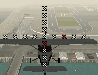
When in ILS range, several X symbols will be shown in a + formation. On both the horizontal and vertical axis, one X will be red, indicating the position of the optimal guideslope.
If the red X on the horizontal axis is to the right, the aircraft is too far left. If the red X on the vertical axis is below the center, the aircraft is too high. When the value is out of range, a number will be shown to give an idea of how much out of position the aircraft is.
The goal is to keep both red Xs in the center, because that means the aircraft
is right on the optimal glideslope.

In the image above, the optimal glideslope is slightly below and to the right, so the plane is a bit too high and slightly off the centerline.
When the aircraft is out of the ILS range, a 'No signal' text will show.

Examples
When the aircraft is nicely in the middle, both horizontally and vertically, the
ILS indicator will show the middle X in red.

When the aircraft is slightly to the left of the centerline, the red X on the
horizontal axis is slightly towards the right because that's where the ideal
position is. The same applies to the vertical axis, the red X will be slightly
above the center when the aircraft is slightly too low.

When the aircraft is far to the right, there will be no red X on the horizontal axis for the horizontal deviation, but a number giving a slight indication how far off the positioning is. Note that there IS still a red X on the horizontal axis, but this is the indicator for the vertical axis, showing that the aircraft is nicely in the middle of the vertical glidescope.
The same applies for the vertical axis, a number will show at the top or bottom
if the aircraft's height is very far from the ideal height.

When the aircraft is completely out of range of the ILS signal, either
horizontally or vertically, the indicator will hide and a No ILS signal
text will appear.

| Category: Navigation | |
|---|---|
| ADF (Automatic Direction Finder) • ILS (Instrument Landing System) • List of beacons • VOR (VHF Omnidirectional Range) | |
This article has been accessed 3457 time(s).
Main page Article index
